We’ve taken a branch off our main road to head for an aire that seemed off the beaten track, therefore less busy, therefore get a decent night’s sleep after last night in Sisteron.
This is a tiny little town called Fontaine de Vaucluse, and it has an aire for about 30 motorhomes. It also has the most complex entry/pay/security system we’ve ever come across. We joined the small queue of vans waiting to get in; the hold up being people unable to get the entry machine to do their bidding and make the barrier go up. We did eventually manage to get in, though we never got the “gratuit” Internet access that was allegedly available.
Another fabulous and interesting town. There’s a river through the town that’s absolutely crystal clear. It’s probably the clearest river I’ve ever seen. It’s not a small river – probably 20 m across, yet it rises from the foot of the cliffs 300m upstream of the town. It’s apparently the largest spring in the whole of Europe. And it doesn’t end there. There’s a footpath that runs alongside the river/cascade, past the main spring(s), and leads you to a cave at the foot of the cliffs. You can’t really get into the cave as it’s more like a vertical hole. And it’s full of water. Just a still water surface. A couple of times a year, the water level in the cave rises. And rises, and rises. By some 20 m or so. It then overflows from the cave and cascades down to join the rest of the river. This is – it is said – an awe-inspiring sight.
The VaucluseThe Vaucluse rises from a cave at the bottom of this cliff
The cave itself has been explored many times; the first dive taking place in 1853, from which it was established that the floor of the cave was 24m down. The next dive established a floor at 32m down. Subsequent dives over the years have explored further and further down, the most recent in depth being determined in 1985 as being 308m by remote control diving vehicle. Further explorations 2003 and 2004 revealed hundreds of Roman coins and other artefacts that were retrieved. The full extent of the cave system is still unknown, as is the cause of the twice yearly flooding of the cave. Fascinating.
Getting out of the aire in the morning was no easier than getting in. Especially as there were motorhomes trying to get in & thus blocking the only way out. In fact, the people trying to get in called out the Gendarmerie as they’d paid twice and STILL the barrier wouldn’t let them in!
Needless to say, we eventually made good our exit and continued to head South – the temperature rising all the time, reaching a very pleasant 29 degrees by the time we reached our chosen destination of Saintes Maries de la Mer.
We left Chamrousse somewhat late in the day. We’d identified a couple of Aires around Gap & Sisteron that might be useful stopovers on our way South. There is an unfortunate lack of Aires in this area so we were keeping our fingers crossed, especially as the ones we could find on ProMobile didn’t have great reviews.
The Route Napoleon runs from Vizille – South of Grenoble – down to Cannes in Provence, following an often perilously twisty course through several lumpy bits of France. We drove the entire length of it back in 1982: after a lengthy training course in Grenoble, I’d booked a holiday cottage in a miniscule village called Gigaro, about 10km to the South of St Tropez. That was in a Ford Cortina 2l Estate with loads of spare power. This time, we were only going to a point to the South of Sisteron before branching off towards the Camargue. And in a huge van with very little spare power. Slightly worrying, as the map showed the bit through Vizille as being unsuitable for large vehicles. It all worked out in the end as “large vehicles” turned out to mean over 26 tonnes. Even we don’t stretch anywhere close to that.
We reached Gap. Gap has two aires: The first one turned out to be a supermarket car park, inhabited by a large number of darkly dubious types. A quick about-turn and search for the second one. Yet again, her up the windscreen messed us around, taking us down a tiny road on exactly the wrong side of the railway line, before the road ended in a no-entry sign. I may have mentioned it before, but doing a 3-point turn in narrow roads is not our vehicle’s best selling point. Despite having a reversing camera, I managed to snap the end off our waste tank drain-pipe, clipped so conveniently to the underside when I hit the bank. Bugger.
We found the other Aire: It had 4 motorhomes in it and was full. There were two other vans seemingly queuing for a space. So we headed further South.
We reached Sisteron at about 7:30pm and found the Aire at the side of the main road. There were 4 places available, one of which was taken up by a Spanish truck. We grabbed the best space of the rest.
It wasn’t a peaceful night. We were right next to (i.e. 2 metres away) from the main road, and it was very busy. We walked into Sisteron to take a quick look and found it to be yet another of those wonderful places you could easily spend a couple of days in. The aire / car park was perched on top of the old city walls. About 30 metres vertically below us was the ancient road crossing the river, and 200 m down the road was the ancient portal (now removed) through which the old road used to pass under the cliff to reach the town.
Across the river
Wonderful old part to the town, with slightly Moorish appearance, very narrow streets, and a citadel perched high up above the town. The next morning, we went on a hunt for a boulangerie and spent some time in the market buying fruit. The market was causing havoc for the traffic through the town, and we had still to drive through the town!
The Citadel, Sisteron
Tired, with lack of sleep we headed further South, branching off the Route Napolean at Chateau-Arnoux St-Auban.
Thursday dawned well. We (eventually) decided we were going to walk to Lacs Roberts – over the hills and far, far away. Actually, it’s only about 5.5km away – at least, according to the signs. But most of it was fairly vertical and by the time we reached the diminutive Lac des Pourettes (only 2.5km from our start position, allegedly) we were pretty worn out and it was time for lunch. Some of the walking was fairly intense, involving clambering up (and down) steep, rocky sections of path. Neither Joy’s bad knee nor my bad knee were very appreciative of this. It was also pretty hot. After we’d had our packed lunch, we headed back.
As it was still warm, we decided to sit outside – on the terrace of one of the bars. We ordered a (biere de) pression each (draft beer). It was horrible. I asked if they had any other beers: They had and so Joy & I each ordered a different (bottled, this time) beer. This time, they were very good whilst also being very alcoholic at 5.9% and 6.3% respectively. For that little lot, we paid the handsome sum of €20. The two “special” beers (as they turned out to be) were €6 each (for a mere 33cl. Never should you expect to buy French beer cheaply in a bar. Even when the bar is in a ski resort, out of season, and is otherwise deserted.
Fri 29th.
We’re leaving today, but not before I have another ride down one of the mountain bike downhill routes. Joy elected to do the cross-country trail, so I took the tele-cabine up to the top and followed the blue trail down from there. There were a couple of sections I felt I could have done – had I been wearing more body protection; had I been closer to home; etc – but didn’t. The rest of it was good fun but would have been far better on the other bike I left at home (my full-suspension bike).
After filling the van with water, we set off down the Route Napoleon, eventually arriving at Sisteron at about tea-time. But more about that when I next have time (and an Internet connection).
Yesterday was vile. It started raining at about 04:00, and – other than a brief pause, just long enough for Joy to have a quick walk over the nearby hills – it didn’t stop until sometime in the early hours of this morning. The whole time it rained, the large skylight was leaking so we had to have the buckets and bowls out to catch the drips. To be fair, it wasn’t all that cold – probably around 16°C – but it wasn’t pleasant.
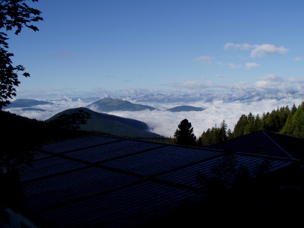
So when I woke up this morning, I could hear it was no longer raining, but I expected it to be grey and overcast. Wrong: there wasn’t a cloud in the sky. At least, not above us. The cloud was all below us, completely blanketing Grenoble and the 3 valleys that converge on Grenoble. We weren’t basking in the sun, however, as it hadn’t yet risen here (there’s a 2250m ridge to the East of where we’re parked). But I did manage to get some photos of the sun rising behind the ski station. The views were truly inspirational and make up for yesterday’s dismal performance!
The cloud below usThe sunrise above usGrenoble must be there somewhereThe sun makes tramlines from the cable car cables
Whilst Joy was walking yesterday, she got chatting to a lady on the hills who was gathering blueberries on the mountainside. Now that the rain had stopped, it seemed like a good idea. So we took off over the hills and far, far away. Well, a couple of kilometres anyway, though much of it was vertical! We spent a couple of hours gathering the tiny berries; a bit of a labour of love as there’s not a great deal of reward for the effort. Still, between us, we managed to pick enough for a decent sized crumble, which has just gone into the oven as I speak (or write!).
Although it had been a fabulous morning, as the day progressed, it seemed as though all the cloud that was in the valleys was rising up towards us. Sometimes, we were totally engulfed in fog and shivering. The next moment, it would clear and we’d be in hot sunshine. Difficult to dress appropriately for the conditions, but scenically awe-inspiring.
The cloud risesThe highest we got today
Whilst blueberry-picking, it was impossible to take a step without several grasshoppers or crickets jumping out from under your feet. I’ve never seen such a variety of shapes, sizes and colours. As the sun warmed up, so did the crickets; their chirruping and hissing accompanying us. We each came across small frogs: olive green and perhaps 3cm long. Makes you wonder what becomes of all the wildlife during the six months of the year the ground is snow-covered?
The forecast for tomorrow is good. Really, it’s the main reason we’re staying on here – hoping for that one good day!
More years ago than I care to admit to, back in my early days as a field computer systems engineer with Hewlett Packard (HP), I spent a lot of time in Grenoble, France. HP had a engineering training centre there that covered everything about computer systems hardware, peripherals, telecoms (that used to mean RS232 in those days), and networking (yes, we had interconnected computers back in 1981, though no-one quite knew what to do about it). Some years, I’d spend enough weeks out of the country in Grenoble to allow me to claim back tax (that’s in the days when such allowances were available – sadly no more) over a tax year.
HP was a great enough company then to even pay for your family to go away with you if you were away on a long (e.g. 4 weeks) training course and opted to take your own (company) car. And so, Joy and Kathryn (pre-Oliver days!) came away to Grenoble almost as many times as I did, staying in the Hotel Alpha in Meylan – on the outskirts of the city. The Alpha used to have kitchenette apartments which we always managed to stay in, so the cost to us as a family was only marginally more than living back home.
We came to really like Grenoble (despite the fact that my car was broken into and my camera was stolen just nearby), and we had plenty of time to explore it and the environs. Grenoble is more or less right at the entrance to the French Alps. It’s in the Haute-Savoie region, and there are the vast National Parks of Ecrins; Vanoise; Chartreuse (yes, where the green stuff comes from); and the Vercors. Not to mention spitting distance to the ski resorts of Les Deux Alpes and Alpe d’Huez, and within easy reach of the Tarentaise Valley with the major resorts of Les Trois Vallees; Valmorel; La Plagne; Les Arcs; Tignes and Val d’Isere. But the very closest ski resort to Grenoble is Chamrousse, just 50 minutes drive from Meylan.
In terms of high resorts, Chamrousse isn’t one of them: The villages of Chamrousse – Le Recoin, and Roche Le Bèranger (which have recently been given the trendy names of Chamrousse 1650 and Chamrousse 1750, respectively) are at a pretty respectable altitude, though the mountains don’t really reach much above 2250m and so the skiing is consequently limited.
Chamrousse has fond memories for us from 1982’ish when we were probably last here, and so it’s long overdue a visit. There happens to be an Aire for motorhomes (only introduced in 2012), with water supply and drainage, and electricity – all for a fairly nominal fee. And so, here we are in the wonderful mountain air, with the summer holiday season just ending and very few people here. The van even made it up the steep & windy mountain road without too many complaints.
Looking down to Grenoble
It’s not all roses, however; in our planning, we completely neglected to take account of the temperature at this altitude, it having been fairly warm lower down. So last night with fog all around us, and the mercury dipping to around 7c, I realised I’d not brought any cold-weather clothes with me. Even my duvet is summer-orientated, so it was a chilly night.
The top ski station – 600m above us.
Mon 25th Aug.
Call me a wimp, but I put the heating on in the van this morning, much to Joy’s disgust. It was only 10°C indoors.
Whilst here, we’d hoped to do some mountain biking and – perhaps – some walking. I guess we’ve missed the ideal time for walking, which must be June – when all the alpine flowers are at their best. Also, the forecast isn’t brilliant: The sunny and 17°C forecast is not in evidence. It’s cold, overcast and there have been a few spots of rain. The forecast for tomorrow & Wed is heavy rain showers.
So today’s the day for all the activities. Out with the bikes, and onto the gentle “cross-country” trail that runs from Chamrousse 1650 to Chamrousse 1600 with only small vertical deviations to test our altitude fitness. The sun came out, and we stopped to take photos of the ponies at the small riding school, with snow-spattered mountains in the background.
The pony school
There are also a number of downhill mountain biking trails here (another reason why we’re here), ranging in difficulty from green, through blue to red, then black. Like ski piste difficulty grading, mountain bike trail grading can be every bit as inconsistent from one place to another. We took our bikes up the gondola ski lift to the top, intending to take the green run – which should be enough of a challenge for Joy.
Just off the ski lift
The map shows a blue run off the top, running along the ridge before splitting off onto red and green alternatives. We didn’t find the green trail and ended up doing the blue for the entire 1st section. Joy struggled with this, but soldiered-on. In my opinion, the blue was equivalent to red+ on the trails I’m used to, so there were some gnarly sections. Quite a few, in fact.
Eventually, we did find the green trail lower down. It was no easier than the blue we’d already done. Fun for me, but hard on Joy. We did get down without any incidents and lived to tell the tale.
A fun little ramp
Internet access is no easier in France than it was in Germany. Worse still, my phone now seems to be playing-up and switching-off the phone signal so I can’t make/receive calls/text messages. I have to keep rebooting it to overcome the problem. However, the Tourist Information office here has a fantastic, free WiFi point. All I need now is to find some time to park myself in the building to do everything I need to do. These last several blog updates come to you courtesy of Chamrousse TI.
A morning of mishaps. A later-than-hoped-for departure from the campsite in Ihringen preceded a drive into town to a supermarket to stock up on essentials (German beer, primarily. But this is a wine region and the beer selection was poor.).
On the way into Ihringen is a petrol station that also sells LPG/Autogas (we have a refillable LPG gas system on the van so we needn’t worry about swapping gas cylinders, which is actually very difficult when crossing country borders as a gas cylinder from one country can’t be swapped/refilled in a different country). The LPG pump displayed a very large notice to the effect that it was illegal to use LPG for anything other than driving the engine. Hmm. I’d heard rumours about this but this was the first time I’d come across it. So we decided to be good citizens and not fill-up our tank here. Less good in the citizenship stakes was that I managed to remove part of the roof over the LPG pump whilst driving away as the overhanging back-end of the van swung out and caught it amidships with a loud cracking sound. Fortunately the van is undamaged other than a few scratches on the awning caused by breaking polycarbonate roof panels. To be fair, the lady in the petrol station was very matter-of-fact about it as we swapped insurance details, and even said she hoped that was the worst thing that would happen to us today. It was. Just.
In the supermarket (as in almost all German supermarkets), there’s a machine for returning your empty plastic bottles, and another for returning your empty beer bottles. Both machines issue credit slips for the refunds on the bottles. These credit slips can be cashed-in at the check-out (smart machines, they have a laser scanner inside them that scans the barcode on the labels, accepting bottles that are recognised, and declining refunds for bottles that aren’t recognised (like the Italian water bottles we’d been toting around, trying to find somewhere to recycle them!). Needless to say, one of the beer bottles failed to make it into the machine and proved no match for the concrete floor it fell upon. Fortunately, we weren’t lacerated by broken shards, and a very nice lady came and cleared away the mess.
With our tails metaphorically between our legs, we hot-footed it out of Germany and into France following guidance from “her on the windscreen”. To be honest, we had no clear idea of where we were heading. “South” was the general idea, but do we go to the Med coast, or to the Atlantic coast? And so undecided, we agreed to head for a place that was close to the “watershed” in terms of road directions: a place from which we could choose either direction. A place I’d never heard of before except as a sticker on the skin of a banana: Dole.
And so we rocked-up in Dole having driven through some beautiful countryside (“she”’s been programmed to keep us off toll roads. i.e. 99.9% of all motorways, and so we’re sticking to the main roads, most of which are really good). Much of the route was alongside the river Doubs. We parked-up at the aire along with about 20 or so other motorhomes. No facilities, but completely free of charge.
Pretty as a picture
The aire was situated between the river Doubs and the Rhine-Rhone canal, which – in Dole – formed part of the town’s defences in earlier times. It was also next to the Stade de Sport. We’d arrived just in time to see two teams coming out of the sports hall changing rooms – each team dressed in their own team colours – and make their ways 10 metres or so onto the car park which also turned out to be a boules piste. Yes – they wear team colours here for boules matches (Pat & Gaynor take note!).
Unfortunately, the aire was also adjoining a fairly busy road that continued to be used throughout the night. A bit noisy, but not too bad. At least not until an emergency vehicle went past with alarm going. I didn’t sleep too well.
Sat23rd Aug
This morning, I wandered up into the town to find a boulangerie for an obligatory roof-of-the-mouth-shredding baguette, a croissant and a pain aux chocolat. It was a steep climb up – what I realised to be – a very ancient street. There was a hotel that used to be the town mill on a branch of the river diverted into the lower town in the 13th century. But there wasn’t a boulangerie, neither ancient nor modern. At the top of the town is the most imposing church of Notre Dame – and enormous church, originally from the 16th century and rebuilt many times – the last restoration being between 2002 and 2005. Eventually, I managed to procure the required baked items & returned for breakfast.
The Notre Dame church towering above yet another “Little Venice”The inner “river”
After breakfast (i.e. practically lunchtime) we decided we’d both explore the town in some more detail. I don’t know how we do it, but almost every place we happen to stop in is fabulous in some way. In addition to the church, Louis Pasteur was born here – the house of his birth (a tannery) is now a museum. The town used to be the principal town of Bourgogne for many centuries. It’s a beautiful and famous town, and I’d never even heard of it.
To Louis Pasteur’s birthplace
Destination programmed in – somewhere North of Bourg-En-Bresse. We’ve decided to head down to the Med. However, we have decided to take a detour off into the alps en-route and we found a convenient Camping Municipale in St Etienne – just to the N of Bourg-En-Bresse – in which to pass the night.
Well, we DID make it into France, but then beat a hasty retreat back into Germany!
Actually, it turned out to be such a warm morning, that we decided to stay another day and do some cycling around this very flat part of the Kaiserstuhl. That and it was pretty late by the time we managed to get ourselves some breakfast (that’s after I’d cycled into Ihringen and back to get some Pretzeln and Brötchen (bread rolls).
With Breisach am Rhein as our destination, we followed the “official” cycle routes taking us mostly over field tracks.
This area is full of agriculture and viticulture; any slightly South-facing slope is covered in vineyards, and there are many slopes here. Ok, I said it was flat, but Ihringen is the place where the lava flows from the dormant-for-the-last-n-million-years volcanos stopped. So the land jacks up steeply just to the North of Ihringen. Any ground that’s flat is covered in orchards or maize. There are plums, apples, pears, mirabelles, and more plums. Much of this is ripening right now; the air is heady with the scent of ripe fruit and the farmers are all out harvesting. Fancy a pear? Helping yourself to one is fine as long as you don’t take the mickey and start harvesting them all! Forget the industrial scale of farms we have in the UK: most of these farmers have anything from a field of fruit trees to a row or two of redcurrant bushes, and most of them sell direct to the public. Who needs food miles?
The vineyards beyond the corn fields
Let me say it here; Breisach is another beautiful town. Perched on the Rhine overlooking France, it has a Münster sitting atop its highest point, surrounded by the old town walls and enclosing steep cobbled streets. An ancient portal through the walls still exists through which cars can now pass (just!). When we were there, they were holding their Jahresmarkt (annual market – though I strongly suspect it’s held several times a year). It was pretty rubbish, really. Apart from the cheese stall.
The Münster
Entertainment was provided by a seller of some new miracle car polish he was continually demonstrating with an old VW Golf for the benefit of the gathered throngs (i.e. no-one in particular). I didn’t take a close look at the product, but I sincerely hope it came with very large “Extremely dangerous and highly inflammable” warning notices plastered all over it. I say this because the seller demonstrated the flammability of it. I don’t know how it happened, but his bottle of stuff – which had a long spout – was in flames on the ground. The bottle itself was burning as well as the vapours, which were increasing in pressure inside the burning bottle as a result of the heat. He then tried to set his trousers on fire by standing on the bottle. The result of this was to eject more of the flammable liquid from the spout all over the pavement and thus spread the flames further. He then had the bright idea of pouring water on the whole. So now, the flaming fuel was spread even further on top of a river of water. Very smart. We beat a hasty retreat to a safe distance, anticipating the bottle would soon rupture or explode. In the meantime, he then decided to throw a rag on the flames. This would have been a good move had the rag not also been flammable, but then he threw more water over the rag which did eventually starve the flames and thus was Breisach saved.
Most of the market was just tat, so we wandered off to find a Bäckerei to get a sandwich. In this, we were wholly unsuccessful. We did, however, end up with a large slice of Käsekuchen (cheesecake) plus a buttered Pretzel each, so we wandered over to the Rhine to eat. And watch the swans. There were hundreds of them, mostly on the French side of the river.
Just for a lark, we decided to cycle over the Rhine and into France. In doing so, we discovered three petrol stations on the German side, practically shoulder-to-shoulder. This arrangement usually occurs when fuel on one side of the border is much cheaper than the other side. But everything I’d read suggested that diesel is cheaper in France than in Germany. So we decided to go further into France to find a French petrol station. We were wholly unsuccessful in this endeavour, too. Not a single petrol to be found within a 15 minute riding distance of the border. In fact, PETROL is more expensive in France, but DIESEL is cheaper (allegedly).
The Rhine here is not actually just the Rhine. That would be far too simple. There are no fewer than 3 bridges over the Rhines, these being:
Yer actual Rhine
The Rhine canal – which goes to and fro, joining up with the Rhine whenever it takes its fancy
Something very wide & turbulent – probably being fed from the bit of Rhine canal – that seems to be driving a number of underwater, power-generating turbines. I guessed this from the facts that there were a lot of electricity power distribution transformers alongside the “weir”, and that there were EDF logos all over the installation.
Yer actual Rhine. With substantial weir.
The first bridge is obviously German. It has a generous cycle path in addition to a footpath. The second & 3rd bridges are equally obviously French. They just have narrow footpaths and cunningly hidden signs displaying graphics that supposedly suggest cyclists dismount and walk the footpath. This we only discovered when one officious lady pointed out the sign to us as we came off on the French side. Clearly we survived to see another day, but the ride was “entertaining”.
So tomorrow, we’ll head over into France (déjà vue…).
We’d stayed with Kathryn & family for the last few days – getting back there in good time for Clara’s 2nd birthday.
We planned to move on today, possibly staying for a few days in the Schwarzwald. Kathryn suggested we all visit the Vogtsbauernhof museum in Hausach, as that would be on our way.
The museum is a collection of traditional Black Forest farmer’s houses (Bauernhöfer) – the earliest of which dates back to 1599. All but one of these houses were moved (yes, really!) to this site after it opened as a museum in 1964. The last family stayed in the house until 1965 – Barbara Abele being the eldest member – and some of the family’s living accommodation has been left as of that period. The traditional design hasn’t really changed since the 16th century and there are many such houses still in use today in the Black Forest:
Thee houses are all built into the hillside, often with the upper loft level being accessed from a road or track at the rear (uphill) side. They all have space for cattle, pigs, goats, and whatever else the farmer may have wished to keep. And there’s living accommodation for (typically) 8 – 12 people; family and farmworkers. They were built without chimneys. There were usually one or two open ranges in the large kitchen, and the smoke was allowed to disperse throughout the house. Above the ranges was a hood. Just a hood, not an extractor. In this hood, they hung meat – traditionally ham – in order to smoke, and hence, preserve it. So today, when you buy genuine Schwarzwälder Schinken (smoked ham), you’ll have a better idea of it’s heritage.
These are not small houses. They can be 100m by 75m, and have 3, 4 or 5 floors including the loft(s). Apparently, it took some 400-500 trees to build one of the farmhouses. It’s just as well there are a lot of trees in the Schwarzwald.
The original Bauernhof at Hausach, built in 1612Detail of the front (facing into the valley) of the 1599 BauernhofOne of the many still-in-use Bauernhöfe in the Black ForestOne of the many still-in-use Bauernhöfe in the Black Forest
Kathryn & family departed for home. As the car park ticket for the museum was valid for 24 hrs, we decided to sleep there overnight. Our plan was to drive down to Titisee – further South in the Black Forest – the next morning and spend a few days there.
Mon 18th
Plan into action: We headed South from Hausach, the road climbing all the while. There were some serious climbs that I wasn’t entirely confident the van would make. It coped ok, though often screaming at 3500rpm doing 20mph in 2nd gear.
It had been a fairly chilly start in Hausach, and I couldn’t help but notice that we were doing a lot of climbing. I’ve also learned that the higher the altitude, the colder it generally gets. By the time we got to Triberg (Any tour you make to the Black Forest WILL include Triberg with its waterfalls and cuckoo clocks) we were at 680m above sea level and it was very cold. Time for a pause and reconsider our plan.,,
Titisee lies at 1190m. It was only about 7°C in Triberg. It was going to be colder in Titisee. We consulted the forecast using my ultra-speedy Edeka SIM card in my smartphone. When we did eventually get a phone signal good enough to give us an Internet connection, we could see it was not promising over the next several days.
So… There’s an area between the Black Forest and the Rhine / French border that’s allegedly the warmest part of Germany – The Kaiserstuhl. It’s a well-known (within Germany) wine-producing area and part of the Baden wine region. We’d not yet reached the road junction where we’d need to go either one way or the other. I.e. we were still on track for both possibilities, so no need to go back on ourselves.
As we climbed higher and it got colder still, there was no question. Decision made: head for the Kaiserstuhl. We made it to a very nice but not inexpensive campsite just outside Ihringen – about 30km from Freiburg. It provides free access to the adjoining Freibad (open-air swimming pool).
Tue 19th
Lay round the pool in the 22° of sunshine and had a beer on the terrace in the evening. Could it be we made the right decision in coming here? Cracked open a not inexpensive bottle of local wine – a Spätburgunder Weissherbst. A rosé we’ve had many times. This one was one of the least good. Can’t win ’em all.
Wed 20th
Part of the fee for staying on this campsite is a one-off tax of €1.70 per person. For this, in return, you get access to the Freibad; two free wine cellar tours with tastings (unfortunately only on days we’ll not be here); and – this is the biggy – completely free use of public transport throughout the Black Forest (with some conditions, obviously).
When we were at the Bauernhof museum the other day, I’d noticed the railway line snaking along the side of the road. We also noticed on the road map that it did a couple of convoluted loops at two points close by. Something that seemed worth investigating at first hand. And if we could do it for free…
So I spent an hour or so online looking at train timetables and connections and discovered it would be possible to do an entire loop through the Black Forest in one day. One or two of the connections would be tight, but it seemed do-able. And it would – of course – include the Schwarzwaldbahn that runs from Donaueschingen, heading NW through the Black Forest to Offenburg, past Hausach. All we had to do was to avoid any high-speed trains; inter-regional trains and some other kind of train I could find anything out about. We needed no tickets; only needing to show our Guest Card and photo ID to the conductor should we be asked.
A picture postcard Schwarzwald villageAnother Schwalzwald Bauernhof
It all worked perfectly. Ihringen to Freiburg. Freiburg to Neustadt. Neustadt to Donaueschingen. Donaueschingem to Offenburg, Offenburg to Frieburg, and Freiburg back to Ihringen. Six train connections, and all of them worked out ok. We had a 1 1/2 hour break at Donaueschingen – conveniently at lunchtime – giving us time to find a Gasthof and have a Käsespätzle (sorry – can’t be translated. Ask Joy to make some for you!) mit Röstzwiebeln (with roasted onions) each. Heavy fare, but very good.
The train journey was great, but perhaps not as great as I’d hoped. The two loops by Triberg passed by without my noticing them, and the train we were on had high-backed seats – very comfortable, but not great for spotting up-coming attractions as you couldn’t see past the seat in front. It turns out that the two loops are largely inside tunnels and they are done to gain/lose altitude in as tight a space as possible – a bit like planes circling over Kent waiting to land at Heathrow. The cost of the tickets for this journey, had we had to buy them, would have been around €65 each. Thank you Schwarzwald tourismus.
We’re now looking at heading out into France and somewhere warmer tomorrow, but the mad European weather is still holding firm. Even if we head to the far SW of France – near Bayonne / Biarritz – it’s still only 19°/20° for the next several days. Maybe we’ll head that way anyway and hope that – by the time we get there, which could be several days hence – it might warm up a bit (or a lot).
We’ll probably be without Internet again for much of the uncertain future. My German SIM card won’t work far into France, so not sure when I might be able to continue the story…
A very short drive has brought us to Igelsbachsee – a smaller lake separated from the larger Brombachsee by a dam/causeway.
Again; an excellent Stellplatz above the lake (it’s a stiff climb from the lake back to the Stellplatz) for up to 50 motorhomes. There are just 3 motorhomes here including ourselves. Not a single car in the car park. A ghost of an August. It’s cold and it’s raining.
In the morning, just time for a walk down to the lake and across the causeways.
A Plan of the lakes. We’re by Enderndorf on the join between Brombachsee and Igelsbachsee
There’s a fantastic marine vehicle just off the sandy beach. It’s a boat of some kind. I though at first it was some kind of dredger, but watching it, it became apparent that it was weeding the lake bed in front of the beach. Only in Germany! This is meant as a complement: The fastidiousness that compels them to clear the weeds from the bathing area for tourists at such enormous cost (heaven knows how much the machine cost) is quite something.
Weeding Igelsbachsee
And in the afternoon – back to Ehningen in time for Clara’s 2nd birthday.
The weather has turned. Following Sun night’s downpours, it’s gone much cooler. Not the best time to be touring the Fränkische Seeland but it’s only 1 1/2 hours away from Heiligenstadt and just to the South of Nuremberg. We’ve decided not to “do” Nuremberg and Munich for several reasons, so this gives us 3 days to enjoy the area before heading back to Ehningen for Clara’s 2nd birthday.
We found an excellent Stellplatz in Heubach; near Hilpoltstein. It’s about 150m from the edge of the lake (Rothsee). Hilpoltstein is within easy cycling distance, just over the other side of the Main-Donau Kanal.
The Rathaus, Hilpoltstein
Hilpoltstein – yet another unspoilt and very old town centre with all the shops we would need. The Brauerei Gasthof zum schwarzen Ross (sadly no longer a brewery) houses a small museum that was unfortunately closed whilst we were there. In fact, much of Hilpotstein was closed or about to close for the rest of August.
Brauerei Gasthof zum Shwarzen Ross
The Gasthof clearly used to be a coaching house containing a yard (Hof) with what used to be stables. There’s a public footpath running from the road, through the Hof and down some steps at the back through part of what used to be the old town walls. There are also the remnants of a moat just outside the wall.
We stay for a beer but it’s pretty cool so we decide to head back to the van for tea.
More rain and a cold night followed by a bike ride around the lake in the morning. There are a couple of nature reserves around the lake and they’re full of geese and ducks.
The garden of a private house on Rothsee stopped us in our tracks
A great pity the weather’s so cool: the lake is really warm, there’s a sandy beach, kid’s playground, bar/cafe, sailing club and boat hire. Clearly a very popular holiday destination, but pretty deserted right now – and it’s the middle of August, for goodness sake.
A deserted lakeside: Rothsee at Heubach
When we cycled on the bridge across the Main-Donau Kanal, we noticed a lock a few hundred metres away so decided to go and take a look.
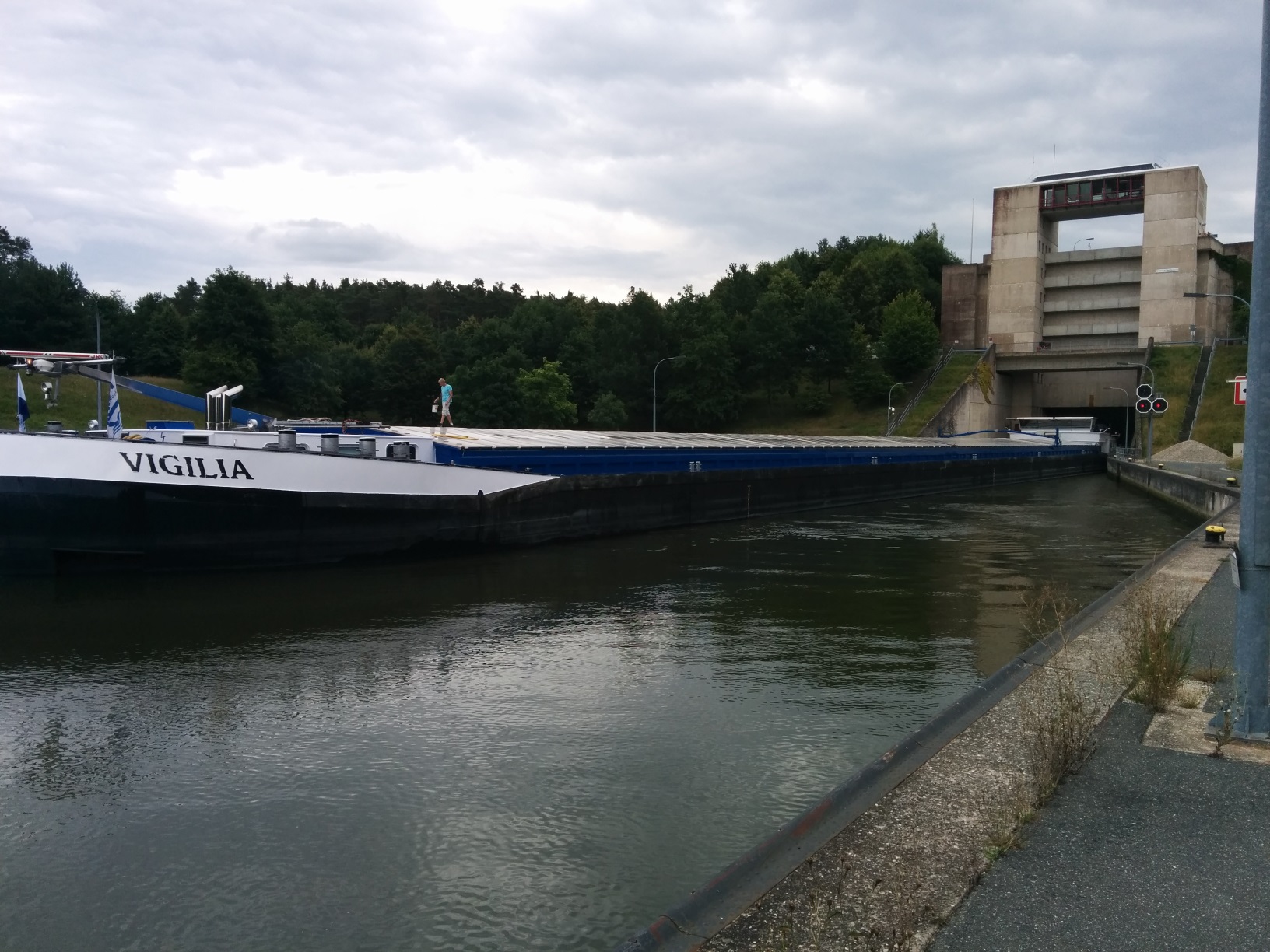
As I may already have mentioned, the barges travelling the canal can be up to 190 m long and 12 m wide. That is big. What I hadn’t realised from the road is that the lock drops the canal by a staggering 25 m (near enough 80 feet). We were lucky enough to catch a big barge negotiating the lock, and the builders of the lock were kind enough to provide a viewing platform. It would have been rude not to watch.
Approaching the top lock gate
We missed the barge entering the lock but saw the top lock gate rise up from the canal behind the ship’s stern. This was clearly not like any lock I’d ever seen before.
We quickly walked down to the far (lower) end of the lock and had to climb several flights of stairs to reach the viewing platform. By the time we got there, the lock was already half empty and we were staring down the dizzying sides at the slowly descending barge.
It looks like a toy in this photo, but this 190m long barge is dwarfed by the scale of the lock
Eventually the lock was low enough and the lower door opened: The entire steel lower section – probably 50 or 60 tonnes-worth of steel – lifts up on chains providing a gap just large enough for the barge to fit under.
The barge emerges from the lock. The man on the front of the barge provides some idea of the scale.
For the technically-minded, here are some details of the lock:
Dimensions: 200m x 12m (useable width) x 24.75m drop
Water volume: 60,639 cubic metres
Water usage per navigation: 24,698 cubic metres
Water level rise/fall rate: 1.5m/minute
Built between 1980 and 1985.
First used (when the canal opened): 1991
Time to negotiate: 25mins
Unlike locks on our canals at home, where water must always be pumped up to the highest level and all the water from the lock is allowed to flow out of the lock (and is therefore “lost”), this locks preserves most of the water from each use by a very clever system of emptying it successively into 3 huge adjacent storage tanks set at varying heights corresponding to the water-level heights in the lock. This way, water can flow under gravity from the lock into the highest tank first, then – as the lock level drops, the top tank is sealed and water can then flow under gravity into the middle storage tank. Similarly for the 3rd (lowest) tank. When the lock is being filled, this whole process then runs in reverse. By this means, most of the water per navigation is preserved, and minimal energy is required for pumping. Clever stuff.
Sleep was disturbed by a family with 2 kids & 2 dogs who’d parked very close by: To be fair, they weren’t particularly noisy but a group of people 5 metres away chatting and laughing into the night when sound travels easily is a bit annoying.